


Braille maps
The 1874 Annual Report for the Royal Victorian Institute for the Blind holds the first recorded description of the use of Braille in Australia.

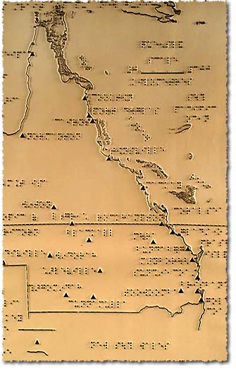
Braille map of Australia
In the 1960s, Mr RF Tunley compiled a crude but amazing small map of Australia. The map was a carved shape of Australia labelled with aluminium tabs, produced on a Crab Braille Machine. It was a double sided map, framed and originally produced for the children at Narbethong, a school in the locality of Buranda in Brisbane, Queensland.
Need for low-vision mapping realised
It wasn’t until the early 1980s that low-vision mapping began to be produced in Queensland. It gave the visually impaired new opportunities to access knowledge in tactile or tactual formats.
In 1982, low-vision maps were produced by the department over QEII stadium as part of the 1982 Commonwealth Games.
The Queensland Tactual Mapping Committee was formed in 1985 to investigate the need for low-vision maps.
The 1980s saw Australia lead the world in tactual mapping. A national specification for tactual and low vision maps was developed paying particular attention to line size, symbols, patterns and Braille placement.
The department in conjunction with the Queensland Tactual Mapping Committee produced over 60 tactual maps for the visually impaired people of Queensland between 1985 and 2000. Tactual maps are usually printed with a low-vision version on one side and a Braille raised image on the reverse.
Innovative maps for measuring
In 1997, an ancient technique for reading distances on maps was used to produce a new concept of tactual mapping. The product was called 'Measure-It Maps' and was used to measure distances between towns.
"The maps were printed on puff paper which had holes cut out at town locations. These locations were named in Braille. A piece of string was used, having beads at exact intervals along its length. The distance between beads was determined by the map scale. A bead was inserted into a town hole and the distance measured along the string to another appropriate town was noted." (Ghobrial, J 1997 'Measure-It Maps', Cartography, vol. 26 no. 2)
Related links
- Learn about Queensland’s historical mapping processes.
- View images of instruments and equipment used to survey and map Queensland.